

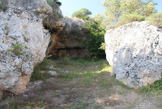
In Apulia, shallow erosive furrows, typical of the Apulian landscape, which convey rainwater from the Murgia plateau towards the closing point of the catchment area to which they belong, are called ‘lame’. Also called ‘lame’ are the terminal sections of ravines, a term that designates deep incisions with steep banks
“Le lame” are usually confused with generic watercourses. The difference between a blade and a watercourse is substantial, since in blades, due to the high porosity of the soil, surface circulation is small, while it is prevalent underground. Furthermore, blades only carry water during rainfall events, collecting water from the catchment area to which they belong, while they are substantially dry during normal periods.
Source: Wikipedia
Thus, “le lame” are poorly developed, flat-bottomed, flared incisions and constitute, together with the ravines, the main valley elements of the Karst landscape and, during rainfall events, collect surface water runoff.
Usually, these tributaries are devoid of water because of the high permeability of the rocks of the carbonate substrate due to the presence of widespread fracturing systems and karst conduits. Due to the aforementioned characteristics, the basins of the blades are poorly hierarchical, discontinuous and generally have a torrential regime.
Curiosity. They are called “lame” precisely because when seen from above (through aerial photography or drones), one can see real incisions in the ground and the geometry of the terrain.

The Example of the Castellana Caves “lame”
The recognisable blades in the vicinity of the Castellana Caves develop predominantly in SW-NE and NW-SE directions, and secondarily in N-S direction: the larger ones, in particular, belong to the first orientation system and receive, from both sides, contributions from the second system. The largest blade is the one that, starting from the Cupa locality, heads towards Castellana and joins other erosive furrows coming from the Spirito Santo, to then flow into the main blade that heads towards Largo Porta Grande, the most depressed point of the Castellana karst basin. It is indeed here that in the past, during major meteorological events, floods have repeatedly occurred, even disastrous ones with numerous victims, as in the case of November 1896.
And yet, as in much of the Murgia territory, the recognition of epigean morphologies is nowadays quite difficult in the Castellana area as well, due to a series of anthropic activities that are causing a strong degradation of Apulian karstification, sometimes to the point of erasing the typical forms of this karst landscape. Intense phenomena of levelling, filling of morphological depressions and karst cavities, quarrying activities (in some cases illegal), repeated cases of pollution both on the surface and of the underground water table, are unfortunately the order of the day in Apulia, and produce direct, sometimes irreparable effects on the karst landscape.
Importance of “lame”
The blades are characterised by alluvial soils formed over time, which are very fertile, as opposed to the rocky limestone soils typical of the Murgia area. For these reasons, and because of the presence of water, the blades have been the site of human settlements since Neolithic times.
The existence of the blades is due to the karstification of the Apulian region. The highly fractured limestone of the Murge is very permeable to rainwater (the limestone rock itself is impermeable, but when highly fractured, it becomes very permeable). The permeability of the region means that water circulates to a small extent on the surface and for the most part underground. In the blades, water also circulates superficially, but the percentage of water that circulates underground and horizontally follows almost the same path as the blade is prevalent. This is due to the capillary effect (capillary fringe).
The blades also play an important role in hydraulic functionality and at the same time are valuable natural environments, ecological corridors connecting different ecosystems from the Murgia to the sea. The karst network brings habitats of high biodiversity closer to urban contexts, sometimes crossing them.

Tourism and ‘lame’
Precisely because of their exceptional presence on Apulian soils, due to the karst phenomenon that is also rare, the blades were an ideal place for anthropisation and ideal routes for moving or trading in Antiquity. Flanking many ravines in past centuries were ideal sheep-tracks, ready for use and no less important deposits of fertile land suitable for intensive cultivation.
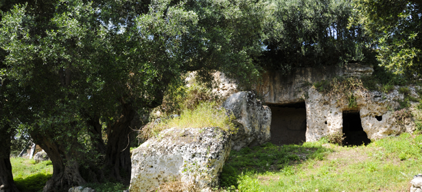
Along the walls of the blades, there are also frequent rock settlements carved into the soft limestone.
Of particular interest is the rock church of Santa Candida, the most important example of the rock phenomenon in the Bari area. The church of Santa Candida, built on the right side of the Picone blade, dates back to the 9th-10th century and is mentioned in the Barese Diplomatic Codex of 1192.
The blades of the Gravine systems of Mottola, Laterza and Matera itself have complex systems of branching and organisation and are clearly visible after major rainfall events. Of these three great complexes of the ravines, for example, it is worth remembering the countless rock churches and urban furnishings used to collect the precious rainwater .
Discover our tour that introduces you to Apulia through its unique territory.
Umanesimo della Pietra
